 Space.
In this part of the paper (as
I said in “abstract”) I will analyze the aspect of Space, thus I will talk
about the different places that are named in the Story.
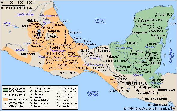
The Hypertext is about Aztec civilization, so most
of the places that I am going to explain below are sited in Mexico, because it
was there where the Aztec Civilization was established.
Here is a list of one of them,
together with a brief explanation.
Azcapotzalco is one of the 16
boroughs into which Mexico's Federal District is divided. Azcapotzalco is
in the northwestern part of Mexico City. It was a town of its own until it was
swallowed up by the burgeoning conurbation of Mexico City.
Today,
Azcapotzalco is divided into many neighborhoods, including Nueva Santa
María, Clavería, San Rafael, El Rosario, Villas de Azcapotzalco, El Recreo,
Pro-Hogar, Obrero Popular and Santa Cruz Acayucan.
· AZTLÁN
Aztlán is the legendary
ancestral home of the Nahua peoples, one of the main cultural groups in
Mesoamerica. "Azteca" is the Nahuatl word for "people from
Aztlan."
Nahuatl legends relate that
seven tribes lived in Chicomoztoc,
or "the place of the seven caves." Each cave represented a different
Nahua group: the Xochimilca, Tlahuica, Acolhua, Tlaxcalan, Tepaneca, Chalca,
and Mexica. Because of a common linguistic origin, those groups also are called
"Nahuatlaca" (Nahua people). These tribes subsequently left the caves
and settled "near" Aztlán, or Aztatlan.
Chapultepec
is a large hill on the outskirts of central Mexico City. It has been a special
place for Mexicans
throughout Mexican history, and it was on this hill that the Aztecs made
a temporary home after arriving from northern Mexico in
the 1200s.
Chapultepec
Park, which consists of the hill and 1,600 acres (6.5 km2) of surrounding land,
has many attractions, including Chapultepec
Castle, where Maximilian I of Mexico and Empress Carlota of Mexico once
lived. The castle's sumptuous interior now houses the National History Museum.
Culhuacan or Colhuacan
was one of the Nahuatl-speaking pre-Columbian city-states of the Valley of
Mexico. By tradition, Culhuacan was founded by the Toltecs
under Mixcoatl,
and that theirs was the first Toltec city (Pohl 1991). The Nahua-speakers
agreed that Culhuacan was the first to title their rulers as
"speaker" (tlatoani).
·
MEXICO
Covering almost 2 million square
kilometres, Mexico is the fifth-largest country in the Americas
by total area and the 14th largest independent nation in the world. With an
estimated population of 109 million, it is the 11th most populous country and
the most populous Spanish-speaking
country in the world. Around 9,000 years ago, ancient indigenous
peoples domesticated corn and initiated an agricultural revolution, leading to
the formation of many complex civilizations. These civilizations revolved
around cities with writing, monumental architecture, astronomical studies,
mathematics, and large militaries. For almost three thousand years, Aridoamerica
and Mesoamerica
were the site of several advanced Amerindian
civilizations.
The Templo
Mayor was the one of the main temples of the Aztecs in their capital city
of Tenochtitlan, which
is now Mexico
City. Its architectural style belongs to the late Postclassic period of Mesoamerica.
The temple was called the huey teocalli in the Nahuatl
language and dedicated simultaneously to two gods, Huitzilopochtli,
god of war and Tlaloc,
god of rain and agriculture, each of which had a shrine at the top of the
pyramid with separate staircases. The temple, measuring approximately 100 by 80
m (330 by 260 ft) at its base, dominated a Sacred Precinct. Construction of the
first temple began in 1390 and was rebuilt six times after that. The temple was
destroyed by the Spanish in 1521. The modern-day archeological site lies just
to the northeast of the Zocalo, or main plaza of Mexico
City, on the corner of what are now Seminario and Justo Sierra streets.
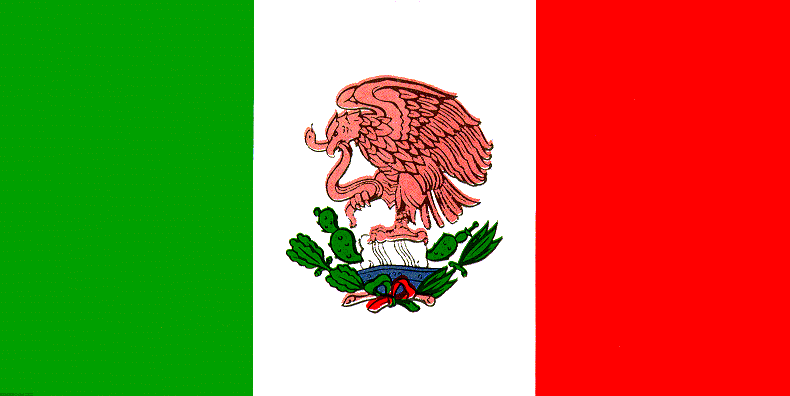
Tenochtitlan
was the capital city of the Aztec
civilization, consisting of the Mexica people, founded in 1325. The state
religion of the Aztec
civilization awaited the fulfillment of an ancient prophecy: that the
wandering tribes would find the destined site for a great city whose location
would be signaled by an eagle eating a snake while perched atop a cactus. The Aztecs saw this vision on what
was then a small swampy island in Lake
Texcoco, a vision that is now immortalized in is Mexico's coat of arms
and on the Mexican flag. Not
deterred by the unfavourable terrain, they set about building their city, using
the chinampa system (misnamed
as "floating gardens") for agriculture and to dry and expand the
island.
A thriving culture developed, and
the Aztec
civilization came to dominate other tribes all around Mexico. The small
natural island was perpetually enlarged as Tenochtitlan grew to become the
largest and most powerful city in Mesoamerica.
Commercial routes were developed that brought goods from places as far as the Gulf of Mexico, the Pacific Ocean and
perhaps even the Inca
Empire.
· TEXCOCO
Texcoco is
a municipality of Mexico
State, located in the Valley
of Mexico to the east of the national capital, Mexico City. The
municipality's main settlement, the city officially known as Texcoco de Mora,
is also commonly referred to as "Texcoco". The city is built on the
foundations of the original Texcoco, which in the Late Postclassic period of
Mesoamerican chronology was one of the major city-states of the pre-Columbian
Aztec Empire, and one of the founders of the Aztec Triple Alliance.
By the time of the Spanish conquest of Mexico, Texcoco was the one of the largest and
most prestigious cities in the central Mexican plateau region, second only to
the Aztec capital, Tenochtitlan. A
survey of Mesoamerican cities estimated that pre-Conquest Texcoco had a
population of up to 24,000 and occupied an area of 450 hectares. It was here
that the first european school in the American continent was founded by Pedro
de Gante in the first half of the 16th century.
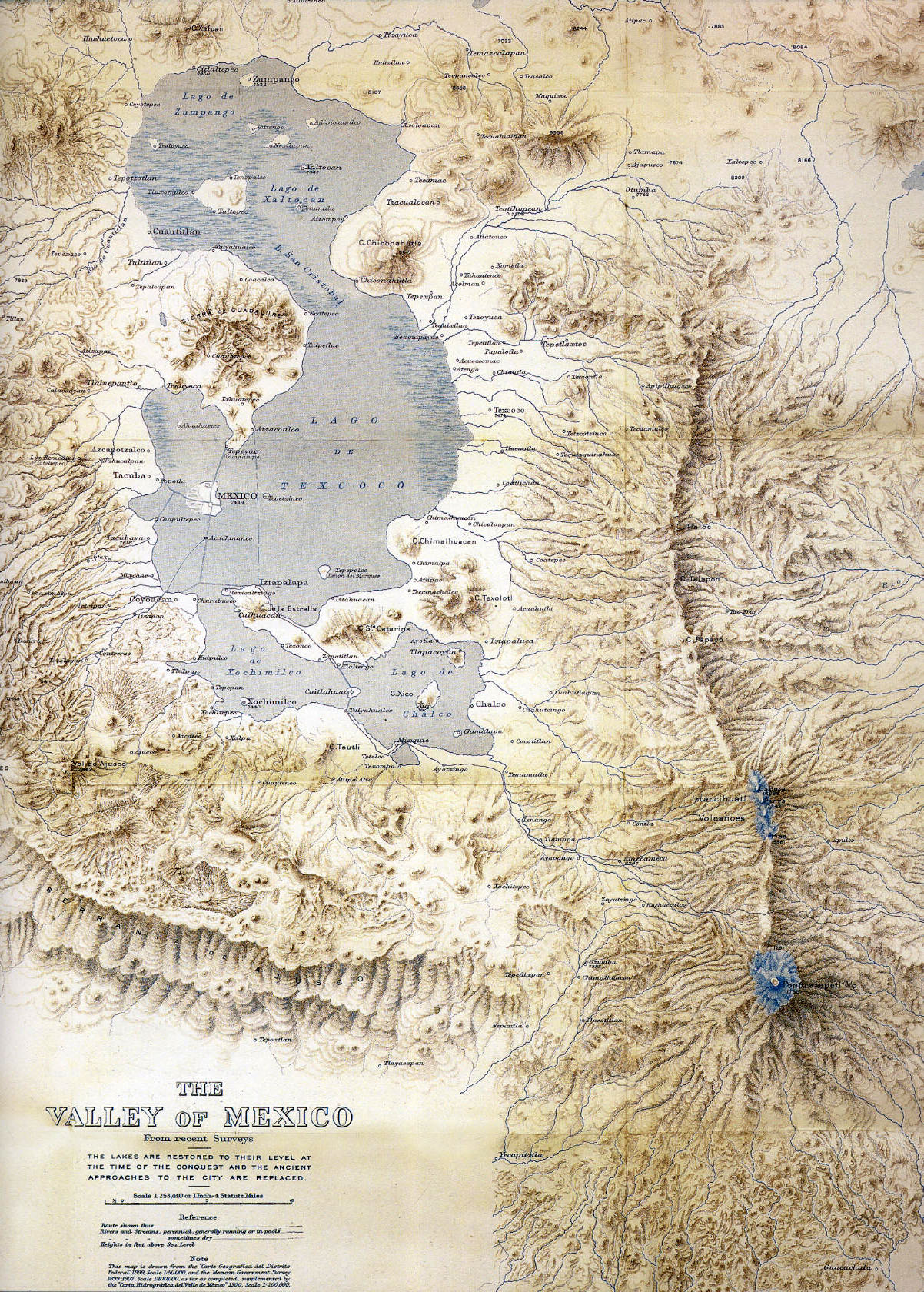
The Valley of
Mexico is located in the Trans-Mexican
Volcanic Belt located in the high plateaus of central Mexico. It has a
minimum altitude of 2,200 meters above sea level and is surrounded by mountains
and volcanoes
that reach elevations of over 5,000 meters. The valley extends for most of the
Mexico City Metropolitan Area, as well as parts of the State of Mexico, Hidalgo, Tlaxcala
and Puebla.
Geologically, it consists of three parts, the old lakebed in the southern part
of the valley, the piedmont which rises up to the mountainsides themselves.
Seismic activity is frequent here.
The Valley of Mexico can be subdivided into four
basins, but the largest and best-studied is the area which contains Mexico City
itself. This section of the valley is also popularly called the Valley of
Mexico. This area used to contain five lakes, Zumpango,
Xaltoca, Xochimilco,
Chalco,
and the largest, Texcoco covering
about 1,500 square kilometers of the valley floor.
The valley has been inhabited for at least 12,000
years, attracting humans with its mild climate, abundant game and ability to
support large-scale agriculture. Civilizations that have arisen in this area
include the Teotihuacan
(800 BCE to 800 CE), the Toltec
Empire (10th to 13th century) and the Aztec
Empire (1325-1521).
SECOND
PAPER INTRODUCTION CONCLUSION
![]()
Academic
year 2008/2009
© a.r.e.a./Dr.Vicente Forés López
© María Vergara Martínez
maverma2@alumni.uv.es
Universitat de València Press